Lamanai – Belize

Lamanai

Lamanai

More on the Maya

Lamanai – Belize

Location

This site is situated on the west bank of the New River lagoon. It is the second-largest site in Belize and, due to its extraordinary setting and architecture, one of the most visited. It is located in an archaeological reserve covering nearly 4 sq km. The name of the site is registered in Spanish sources as Lamanay and Lamayna, possibly a reference to Lama’anayin, which means ‘submerged crocodile’. The same sources also mention the Mayan name for the New River, Dzuluinicob, which Awe translates as ‘strangers’. Lamanai has restrooms, souvenir shops and a largish visitor centre/museum.

Pre-Hispanic history

Lamanai boasts the longest sequence of occupation in Belize: from 900 BC to AD 1675. However, this sequence was not continuous – in AD 1554 the Spaniards arrived and controlled the site for nearly a hundred years until the local population staged an uprising in 1640 and renounced their Christian beliefs. During this period, which can be regarded as a hiatus, the inhabitants of Lamanai struck an alliance with the people of Tipu, an important city in the Cayo district, a few kilometres south of Lamanai.
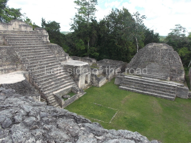
Site description

A tour of this site is extremely enjoyable, taking in the temple of the Masks, the Great Temple, Complex N10, the residential groups, the ball court, the Christian church (16th century) and the site museum. If you have the time and are interested in industrial archaeology, it is worth taking the walk to the 19th century sugar mill a little further south.

Temple of the masks (N9-56).

This is situated in the northern section of the site. The masks on the facade are unique in that their construction technique differs considerably from that used for other Maya masks. Instead of being modelled in stucco on a stone armature, they are made of blocks of limestone and then with a thin layer of grey stucco. Each anthropomorphic face has a headdress representing a crocodile. The presence of this symbol possibly validates the site name registered by the Spanish: Lamanay, ‘place of the crocodile’. Its construction commenced in 200 BC and it was remodelled on several occasions until AD 1300. Inside the temple is a sub-structure from the Preclassic with masks like those found in Structure 5C-2nd at Cerros. Two tombs, one of a male and the other of a female, were found inside the building. The male’s grave goods comprised objects of jade and shell, various textiles, matting and artefacts made of perishable material.

Great Temple (N10-43).

At 33 m, this is the highest structure on the site. The earliest construction, dated to around 100 BC, was of the same height. The building remained largely unchanged until AD 700 and was then abandoned around AD 900. Subsequently, during the Early Postclassic, an offering was placed inside the structure. Complex N10 is a group of residential and administrative structures. The dominant structure of the complex is the building (N10-9) known as the Temple of the Jaguar, built during the Early Classic and remodelled in the Late Classic and Postclassic. At the foot of the stairway are various small altars, the latest additions to the temple dating from after AD 1400. Structures N10-1, 2, 4 and 7 correspond to the Late Classic and Postclassic and had domestic and ceremonial functions. South of Complex N10 lie the main residential groups, which were still inhabited when the Spaniards arrived. These residences accommodated the Lamanai elite. The scattered layout of the houses is very similar to that found in the present-day towns and villages.

Ball Court

In terms of the play area, this is one of the smallest courts and yet it boasts the largest-known marker. A highly unusual offering was found below the marker: a lidded vessel containing miniature vessels and other objects, placed in a pool of mercury. This was the first time that mercury had ever been found in the Maya lowlands and the find was therefore unique. East of the court stands a small temple (N10-27) where Stela 9 was found, face down at the bottom of the temple stairway. Dating from the Late Classic, this is the only stela that was found in its original place. The figure represented is an ancestor of one of the most important Lamanai rulers, Smoking Shell. The stela commemorates the end of year (tun) 7 Ahau 3 Pop and the anniversary of Smoking Shell’s reign. The festivities to mark the occasion took place on 7 March 625 (9.9.12.0.0). The remains of five infants without any traces of violence were found at the foot of the stela. As Awe points out, this offering must have had a special significance because it is unusual to find infant burials associated with the erection of monuments. The original stela can now be found at the entrance to the site museum, which accommodates a collection of artefacts discovered during the excavations. The most outstanding pieces are the Postclassic polychrome ceramics and the eccentric flints.

Christian church.

Known as the Indian Church, this was built by the Spanish with masonry from the pre-Hispanic constructions. The massive walls with their large angular stones are representative of 16th century European architecture. During his excavations, Awe found a cemetery and evidence that in 1544 the Spanish had built an earlier church in the upper part of the one of the temples. In the mid-19th century the area was given over to sugar production. At Lamanai there are remains of a sugar mill with machinery imported from New Orleans in 1868. According to Kelley, the mill was abandoned around 1883 and the area was subsequently exploited for timber until the 1970s.

From: ‘The Maya: an architectural and landscape guide’, produced jointly by the Junta de Andulacia and the Universidad Autonoma de Mexico, 2010, pp271-272, pp274-275.

Lamanai

Lamanai

  1. Temple of the Masks; 2. Great Temple; 3. Ball Court; 4. Temple of the Jaguar.

How to get there;

From Orange Walk. Not easy, especially if you visit during the rainy season and you don;t have access to a 4×4 vehicle. Almost certainly the most convenient, and most attractive, way is to travel by boat from just south of Orange Walk which takes you on a tortuous route through the many channels of the New River to the site, taking in along the way the local wildlife, especially the birds but also crocodiles and turtles. These can be organised locally and cost in the region of B$110 for an excursion which includes transport from your accommodation, the boat trip, lunch and entrance to the site – all accompanied by a local guide.

Entrance;

Included in the tour price but would be B$10 if you arrived independently.

More on the Maya

Caracol – Belize

Caracol

Caracol

More on the Maya

Caracol – Belize

Location

This is the largest archaeological site in Belize and, during the Classic era, it was also the largest urban centre in the region. It was thus named by the British archaeologist A H Anderson due to the abundance of snails [caracoles in Spanish] found on the clay paths amid the ruins. The site is situated on the west face of the Maya Mountains, in the Chiquibul forestry reserve surrounded by the Chiquibul and Macal rivers, in an asymmetrical mountainous area some 500 m above sea level. Due to the wealth of the natural surroundings and its strategic position between the central lowlands and the Caribbean coast, it became one of the most important urban settlements in the Maya area. Over 60 km of sacbeob or Maya causeways have been identified further inland, which were clearly used for trading and communication purposes. This great city and the outlying settlements are thought to have had a combined population of over 100,000 inhabitants. Caracol is situated approximately 120 km from San Ignacio, in the Cayo district. There are two accesses from the Western Highway, with signs indicating the turn-off to the site. To reach the site from the twin towns of San Ignacio and Santa Elena, take the Cristo Rey road via the Yucatec Maya village of San Antonio and then switch to the Chiquibul road. If you take the Western Highway from the capital Belmopan, turn on to the Chiquibul road when you reach Georgeville. This road, which is still not entirely paved, crosses the Mountain Pine Ridge Reserve and leads to the Douglas D’Silva Forest Station in the Rio Frio Caves area. At this point visitors are obliged to report to the control post for escort to the archaeological site as the access route passes through a British military zone deep in the heart of the Maya Mountains. The road to Caracol from the forest station is in fairly good repair and takes you right to the archaeological park. The site has a visitor centre and rest rooms, but there is no food or drink. There is also a simple but interesting site museum that houses a ball court marker with a hieroglyphic inscription, various typical incense burners from the region and other ceramic objects found at the site. A scale model provides visitors with a general idea of the city at a glance and there are also explanatory panels about the archaeological explorations in the area.

History of the explorations

The site was identified in 1939 by Rosa Mai, a logger looking for fine wood. That same year the archaeologist A H Anderson visited the area and christened it Caracol. In the 1950s, the archaeologist Linton Satterthwaite from the University of Pennsylvania conducted excavations at the site to rescue various monuments sculpted in stone. In 1954 the first archaeological commissioner for Belize, Anderson, carried out new excavations and located the funerary chamber, B2. In 1977 the museum of the University of Pennsylvania sent Carl Beetz to finish the work begun by Satterthwaite. A few years later, in 1978, Elizabeth Graham sent a team to rescue monument 21, currently on display at the museum in Belmopan. That same year and the following year, Paul Healy from Trent University investigated the artificial terraces around the site. In 1985 the archaeologists Diane and Arlen Chase from the University of Central Florida embarked on a series of ongoing extensive excavations. Similarly, in recent years the Belize Institute of Archaeology directed by Jaime Awe has consolidated the Caana monumental structure and various stucco masks, such as those on Building B5, have been protected with replicas.

Pre-Hispanic history

The recent discoveries at Caracol have altered our former knowledge of the site. Explorations have demonstrated that the area was densely populated and that the terrain was modified with terraces for cultivation and habitation purposes; the outlying area was connected to the ceremonial centre via a large network of roads built with stone and mortar. Intensive farming provided the local inhabitants an agricultural surplus that favoured the development of a powerful kingdom on a par with Tikal, Calakmul and other smaller sites such as Ucanal, Naranjo and B’ital. The political links with these powers in the Maya lowlands turned Caracol into a key player in the diplomatic and military manoeuvres of the Classic era.

Epigraphic studies have revealed a long dynastic sequence comprising 14 kul ahaw or ‘divine lords’, commencing in the mid-4th century with a figure called Te’ Kab’ Chaac or ‘Tree Branch Rain God’, thought to be the founder of the Caracol dynasty. It would appear that the original name of the city was Oxwitza, ‘Place of Three Hills’. The ruler Ahaw ‘Snail Knot’ left an impressive monumental legacy. The 2-katun (40-year) reign of his brother K’an II, the fifth ruler and perhaps the most successful chief of Caracol, propitiated the development of outlying centres connected to the main centre by a large network of roads. His mother, Lady B’atz Ek’, also played an active role in politics and she is thought to be buried inside Pyramid B19 on the Caana platform.

Other historical data recorded in the stone hieroglyphs are the fall of Caracol as a result of a war with its rival Naranjo, after which it remained in a kind of hiatus lasting 118 years until AD 798, when the local nobility revived their traditions with K’inich Joy K’awil, the ninth figure in line to the throne of Caracol, who captured the ‘divine lords’ of Ucanal and B’ital. This event is recorded on Altar 23 situated at the centre of the site in a provisional place to protect it and other sculptures from the elements. The monuments of the subsequent rulers reveal common thematic and stylistic innovations during the Terminal Classic period, such as shared scenes in which the ruler converses or performs ceremonies in the company of another high ranking figure. According to the epigraphers, this marked a change in the autocratic power to meet new circumstances in which the rulers had to negotiate their position with other leading members of the nobility, either local or foreign, whose power equalled or exceeded their own.

Other important sites in the region ruled by Caracol are La Rejolla, Hatzcap Ceel, Caledonia and Mountain Cow. Caracol was the largest state in the region. By the end of the Maya hiatus, it probably had a larger population than Tikal. The latest inscription at Caracol can be found on Stela 10 and corresponds to the Maya date 10.1.10.0.0 (AD 859). There are no known monuments after this date that mention the heroic feats of the rulling elite, although the destroyed city shows evidence of having continued to be occupied for some time.

Site description

The central area of the site occupies a surface area of 3 sq km. The site reveals great urban growth between AD 550 and 700. During the Late Classic important changes occurred: increased building activity, strong population growth and the development of farming based on a system of raised terraces. At Caracol 4,400 structures have been identified and mapped in an area of 4 sq km. The site is situated 75 km in a straight line from Tikal and 45 km from Naranjo, in Guatemala. The area has a complex network of interconnected roads with various outlying sites around the central area. Several architectural structures at the site have been consolidated and a large number of sculptural monuments have been recovered, providing important historical data about the rulers of this great city.

Visitors enter the area via Group A, which is situated in the west section and comprises more than 12 structures around an enclosed plaza. Interesting to note is the presence of an E-Group or observatory. These structures were used for establishing the points of the solstices and equinoxes, celestial observations closely tied to farming cycles: ploughing, sowing and harvesting. At the centre of the group is a large elongated construction known as Building A6 or ‘Wooden Lintel’. This building displays a long building sequence from the Late Preclassic to the end of the Classic period. At the top of structure A2, on the west side of the plaza, Stela 22 (AD 633) was found; it contains the longest hieroglyphic inscription known in Belize to date. Situated on the south side of this same group is Ball Court A. Floor marker 21 was identified at the centre of the court and holds special significance in the history of Caracol as it records the victories over the ruling lineage of Tikal in April AD 562. The marker was probably dedicated to the accession of the fifth ruler of Caracol, Lord K’an II, commemorating his military victory over his old rival Naranjo in AD 631.

Continuing to the east we arrive at the central acropolis, the Late Classic residential and funerary complex that accommodated the ruling class of this period. Situated at the south end is another large residential group, the south acropolis, which delimits the south side of this central area of the site. Between the two acropolises is a large reservoir, which must have supplied the residential complexes with water. Situated at Group B, in the north-east section of the site, is the largest architectural complex and Caracol’s greatest pyramid, which the archaeologists christened Caana, meaning ‘Sky Place’. This vast construction that stands over 43 m high and dominates Plaza B is the most complex single building on the site and displays multifunctional architecture comprising administrative, residential, funerary and religious spaces. Its main facade has been cleared of rubble and consolidated. Several constructions were built on top of this great pyramid, around a large enclosed court. The buildings in a triadic arrangement on the top reveal the remains of stucco masks and contain vaulted funerary chambers. The massive pyramid also contains several buried constructions, the oldest one dating from around 200 BC. Opposite the Caana building, on the south side of the plaza, stands Building B5. Visible at the sides of the central stairway of this temple are the remains of stucco masks representing the ‘Earth Monster’ or Witz and other deities such as the rain god. These superimposed masks reveal two building phases and provide us with an idea of the profuse decoration on Maya constructions. Also situated in this section is Ball Court B, where four markers have been identified; the hieroglyphic inscriptions on the markers record the accession to the throne of K’inich Joy K’awil, one of the last rulers of the site, in AD 799. Group B also contains a fine masonry construction used as a reservoir. Situated in the north-east area of Group B are structures B2i to B26, identified as the ‘neighbourhood’. This area accommodates two palaces and residential areas corresponding to the Late Classic period (AD 800). There are other residential groups nearby but these are not open to the public

From: ‘The Maya: an architectural and landscape guide’, produced jointly by the Junta de Andulacia and the Universidad Autonoma de Mexico, 2010, pp248-254.

Caracol

Caracol

  1. Group A; 2. Structure A2; 3. Structure A6; 4. Ball Court A; 5. Struture A13; 6. Central Acropolis; 7. South Acropolis; 8. Group B; 9. Caana; 10. Ball Court B; 11. Building B5; 12. Structures B21 to B26.

How to get there:

From San Ignacio. Not easy – if you don’t have your own transport. The only other way is to book on a tour from one of the many agencies in San Ignacio – but they only do trips if they have at least two people. Cost is B$250. This is an all day affair, taking in visits to some of the natural highlights, Price includes lunch and entrance to the site.

GPS:

16d 45’50”N

89d 07’03”W

Entrance:

B$15

More on the Maya

Xunantunich – Belize

Xunantunich

Xunantunich

More on the Maya

Xunantunich – Belize

Location

The name of the site, recently christened by the inhabitants of the nearby town of San Jose Sucotz in the Cayo district, means ‘stone lady’. The site was the civic-ceremonial centre of the regional capital and controlled the important trade route between the River Mopan and the River Belize, the east coast of the Yucatan Peninsula and the Gulf of Honduras. The settlement was established on a hilltop near the river. The developed section consists of four main groups, AD, with the largest pyramids – possibly platforms for temples – situated in Group A; Groups B, C and D correspond to elite residential groups. The Xunantunich ruins are situated on the tourist trail between Belize and the Tikal ruins in Guatemala. The site is located on the edge of the Western Highway, opposite the Maya town of San Jose Sucotz and the beginning of the River Mopan rapids. Access to the site is via the river on a small human-powered ferry. The protected area of the archaeological site has become the only patch of rainforest, due to the excessive felling of trees for cultivation and livestock breeding in this section of the Maya Mountain foothills. The site has a small museum and rest rooms for visitors. On the banks of the River Mopan are several small establishments selling brightly-coloured Maya handicrafts.

Site description

Structure A6 or El Castillo. At 40 m, this is the highest pyramid on the site and its present-day appearance is the result of successive visible modifications to various parts of the platform. The front displays a monumental stairway leading to the first terrace, approximately 10 m above the plaza, where precincts with numerous entrances were built; continuing behind these constructions is the great accumulation of stones and earth that supports the temples of two subsequent building phases, the top one tiring the most recent. The lower temple is adorned with stucco masks, modelled on the friezes at the east mid west ends; these date from an earlier period than the upper rooms. Nowadays the friezes have been covered with authentic copies to protect them while simultaneously exhibiting them to the public. The frieze on the east side is composed of three large terrestrial, solar and Venus-related masks, with the signs for the moon and day between them. Situated Above these records are niches framed by Venus symbols; seated inside the niches are the figures of people who were decapitated towards the end of the Classic period (AD 800-900). Judging from their position, these figures may well represent the Bacabs or ‘skybearers’. The frieze on the west side displays just one and a half of these masks symbolising the sun god. Situated between them is a square frame around an image of the fire god Chaac or Kah’k Chaak, which in turn is framed by bands adorned with the woven mat design, Pop in the Maya language. The upper record also shows the image of a mutilated figure, possibly corresponding to a pauwahtun, as in the frieze on the opposite side.

Group A. This ceremonial group is situated north of the main platform and is arranged around a rectangular plaza delimited on its north side by a palatial complex with vaulted bays and various chambers around a central courtyard. Situated at the east end of the plaza are three pyramid platforms and two low constructions. At .1 much later date the pyramid at the north end gained n small two-bay temple at the front, which has lost its roof, and two stelae and altars were erected inside; the one in the rear bay has survived almost intact, while the front bay still displays a circular altar inside a quadrangular box. At the exact centre of the plaza stands a pyramid platform with four stepped sections the temple at the top has disappeared almost completely – which divides the original plaza into two sections; on the west side, near the north-west corner, lies one of the elongated platforms of Ball Court 2. The west side of the main plaza is delimited by a pyramid whose west side supports one of the platforms of Ball Court 1; the north end of the play area is sealed by a low retaining wall, while the south end is open. Another two medium-sized mounds and the west platform of the second ball court run along the west side of the plaza.

Group B. Situated north-west of the ball court and excavated by Thompson in 1938, this group corresponds to an elite residential unit, nowadays in a poor state of conservation due to the fact that the excavations have remained exposed – without having consolidated the walls – since Thompson’s day. In the 1970s Elizabeth Benson and David Pendergast discovered evidence to suggest that the buildings were still inhabited during the Early Postclassic period (AD 900 to 1200). Half-way along the path leading from Ball Court I to Group B it is possible to see two granite spheres, which would almost certainly have been used in connection with the ritual ball game.

Groups C and D. These are residential groups situated to the south and south-east of El Castillo; judging from the ball court structure that forms part of Group C, this could also have fulfilled civic and ceremonial functions. Eight stelae and two circular altars have been identified in the Group A plaza; two stelae have dates from baktun 10, suggesting that the site continued to be occupied during the 10th century, by which time several important cities in the central lowlands had been abandoned.

From: ‘The Maya: an architectural and landscape guide’, produced jointly by the Junta de Andulacia and the Universidad Autonoma de Mexico, 2010, pp246-248.

Xunantunich

Xunantunich

1. El Castillo; 2. Plaza A-1; 3. Plaza A-2; 4. Plaza A-3; 5. Ball Court 2; 6. Ball Court 1;  7. Group B; 8. group C.

Getting there:

From San Ignacio. You can either take an infrequent bus (B$2) or a collective taxi (B$4) to San Jose Sucotz. From there you cross the River Mopan on a quaint human-powered ferry (free). From the ferry it’s about a mile to the site entrance (15-20 minute walk – uphill).

GPS:

17d 05’ 20” N

89d 08’ 30 W

Entrance:

B$10

More on the Maya