
‘Fat Betty’ on High Blakey Moor
Chapter 14 – Urra to Glaisdale
The day of the wind
The penultimate day. It seems a long time since I arrived in St Bees but now I know I’ve broken the back of the journey – I’ll get to Robin Hood’s Bay if I have to do it on my knees.
But yet another long day. Not a lot of climbing, in fact the only real climb of the day was the first ten minutes after leaving the B+B, but I estimated that I had a trek of something like 30 kilometres to arrive at the day’s goal.
It was a penultimate but also, if everything went to plan, an ultimate day. Accommodation choices in the latter stages of the route were limited, or if they did exist expensive. For that reason I had booked into the YHA at Whitby which meant that I would have to catch a train from Glaisdale in the afternoon and then return the following day to pick up where I had left off. I’d investigated the transport options and considered that, although slightly messy, I could leave my rucksack at Whitby, do the last day’s walk to Robin Hood’s Bay, and then return to Whitby by bus. Ideally I would be able to stay the last couple of nights of the trip in the YHA. I had tried to transfer my booking whilst at Osmotherly but had been told that Whitby was all booked up. I still had a faint hope that I could arrange something later in the afternoon. This is a long and convoluted way of saying that today would be the last day I would walk with a big backpack.
As I said in the last post there was no need to back-track and return to where I had left the C2C route the day before at Clay Bank Top. If you look at the map Urra makes a very ragged triangle with Clay Bank Top and Round Hill being at the other points. The people in the Maltkiln had produced a home-made sketch map which made a lot of sense when placed against the OS of the area. Also talking through the route before I left I knew what to expect. (One thing I meant to, but forgot to, ask about before leaving was the pronunciation of the word Urra, whether it had a long or a short U. So I still don’t know how to pronounce the name of the place.)
The first ten minutes was steep through overgrown bracken. I think the only people who make that route might be people staying in the Maltkiln as it’s not really on any through route. I have already mentioned the smell of the rotting vegetation that had transferred itself to my skin a couple of days before but here the smell of decay was stronger, probably because the process of death was a little more advanced here, being as Urra is 250m above sea level.
I had been asked to give a final wave once I had reached a wall after which I would be out of sight from the valley. When I thought I was at that point I turned back and saw the flash of their hands waving, surprisingly clear at so far away but standing out against the dark background of the trees. They had been running the place for many years, long before people expected perfection and complete uniformity in their B+Bs, wherever they might be, and had probably been going through the same ritual as guests left for most of that time. I even had my picture taken, all loaded up, just as I was about to leave, making sure that my sandals were in the frame. At the Maltkiln there was a much more individual approach which is becoming a thing of the past now and if they manage to sell up it will disappear in Urra as well. (One of the places I stayed in on the Hadrian’s Wall walk was run in a similar, more laid back and personable manner.)
But as soon as I reached that ridge that left Urra behind I came into a strong wind from the east and that was to dominate the weather all day with no let up whatsoever and with low grey cloud making all the colours seem flat.
Yet again the moors were dominated by shooting as I hadn’t been walking for much more than half an hour before walking along a wide, drivable, sandy track and seeing numbered grouse butts. These were three-sided, rectangular stone structures, with turf on top of the walls, and acted as hides for those with the guns.

Boundary Marker on Urra Moor
Coincidences are said to be more common than we sometimes think they should be and I arrived at the junction with the ‘official’ Coast to Coast route at exactly the same time as an Aussie I had met for the last couple of kilometres of the walk the day before and spent the next couple of hours chatting to him as we headed east along the flat, wind swept moor, eventually following the route of an abandoned railway line. (Also, coincidentally, he had gone to a college in Plymouth just at the time I left.)
It was useful meeting up with him as I probably walked a little faster in company. It had taken me a day or so at the beginning of the route to slow down and adapt to the extra weight. Now, after 12 walking days, I had adopted much more of a plodding pace and keeping pace with him (he carried virtually nothing) meant I made better progress.
I was to make a slight change to my original planned route this day after talking to the people in the Maltkiln. On Blakey High Moor it takes a dive south to then go back up north, for no other reason than to pass by the Lion Inn. Under other circumstances that would have been tempting but not today. There were a lot of kilometres to put behind me and today was unique for all the walking days in that I had transport to catch to take me to my bed for the night. Not an ideal situation but one I’d decided on a good few weeks ago when I was making the arrangements – and had to live with. There was plenty of slack in the timetable but I’d rather spend the time in the pub at the end of a route, knowing that the station was only a couple of minutes away, rather than have a lunchtime beer when I was barely at the half way stage.
So I took a short cut across the moor rather than continue on the disused railway track to the Lion and then trek back up along a busy road. Looking at the map that saved me close on 3 kilometres and if it’s considered cheating, so what? – there’s no official route for the walk anyway and exploration is allowed. This short cut path is not shown in the Stedman book but is quite easy to find once you know what to look for. There’s a long, straight as a die, stretch of the disused railway and just as it makes a curved turn to the right a path crosses it, clearly signposted, and heading down towards the River Esk. If you carry on another 150m or so look out for a flat stone with the letters (in yellow paint) LWW on the left hand side of the track. From this point a faint path, and even some wooden post markers with faint white paint on the top, can be seen heading off to the north-east. (The LWW is for the Lyke Wake Walk and is the route for those who don’t want to call in to the Lion. This is a 40 mile walk from Osmotherly which gets many hundreds of people attempting to do it in 24 hours on the 21st June, the longest day.)
This path is marked on the OS maps and although it becomes indistinct a couple of hundred metres from the railway track as it passes through a swampy area it’s easy to follow if you keep heading north-east and look out for the wooden and even the occasional stone marker. A couple of kilometres and you’ll arrive at the main road at another large, standing stone, the Lion seen back down on the right. The path continues directly across the road, now signposted C2C, and is the best option to pick up the road heading east/south-east above Rosedale Head.
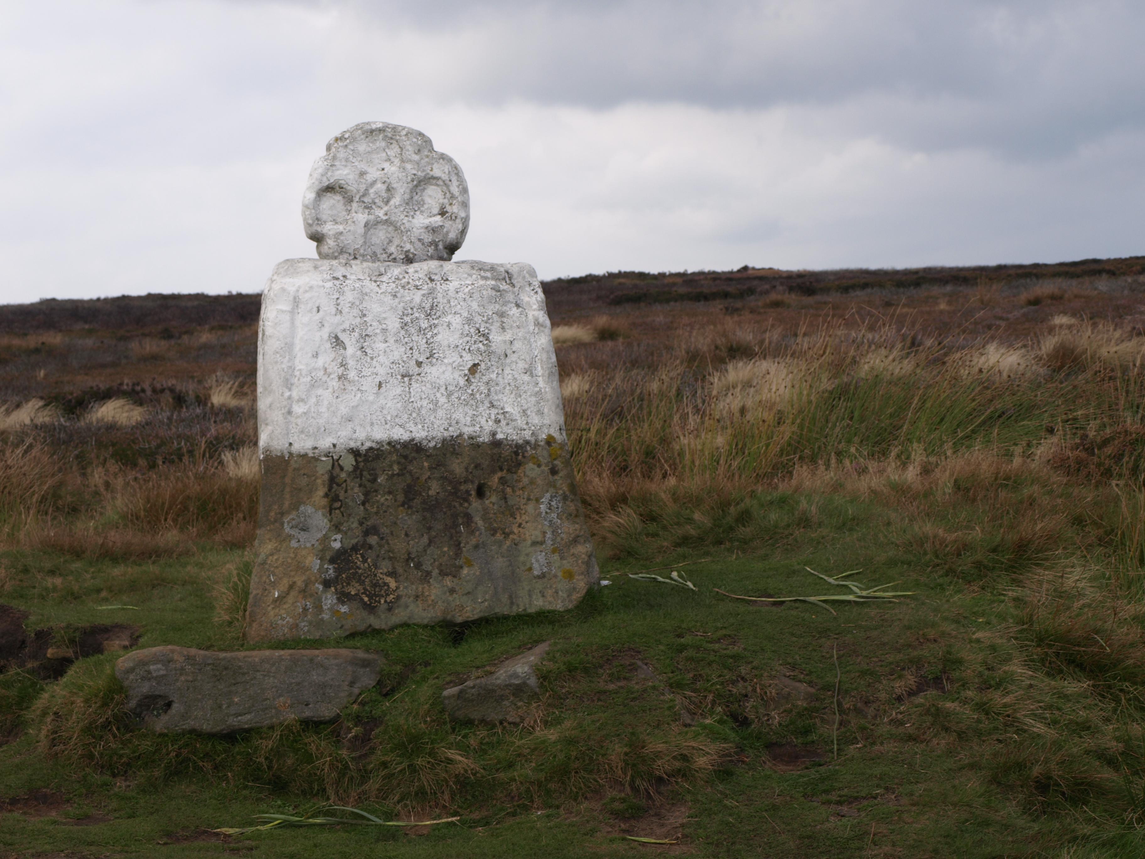
There are a lot of standing stones on this day, in fact on all the days that you walk through the North Yorks Moors. They vary in size and function. Some are boundary markers (and some of those have interesting carvings), some indicate paths or the route of paths and others are just there, often for unknown reasons. After walking across the moorland at Rosedale Head you arrive at a quite road and directly across the road there is a large stone with a smaller one perched on top. The smaller one is circular and has a rough, primitive face carved into it. Now the top half is painted white but how long that’s been the case I don’t know.
This stone is known as ‘Fat Betty’ (and it’s the image at the top of the post). ‘Tradition’ – where do people get all these ‘traditions’? – states that passers-by should take some of the food that had been left there and leave something different in its place. I went against ‘tradition’ for a couple of reasons. A. I didn’t have any food, other than the Mars bar I ate as I sat next to Betty and B. I’m getting too cynical and don’t trust such unknown quantities. You don’t know how long anything might have been there and even if it had only been left a matter of minutes earlier I have passed enough bottles of ‘whiskey’ over the years, half full with amber liquid, to know when to leave well alone. What a comment on our society – or at least my reaction to it?
Another large standing stone is at the next junction, 25 minutes or so along the road. This is called the Millennium Stone and I assume (and hope) it was put up in the year 2000 rather than a much more ancient stone being carved in situ. It has a rough face towards the road but the other face has a cross and the letters AD MM carved into it. At the bottom are the letters NYMA which, I surmise, stands for the North Yorks Moors (or perhaps Millennium) Association. The Christians can’t refrain from vandalising pagan symbols and locations even into the 21st century. When I was in Cuzco in Peru in 1991 I attended a meeting where a speaker was decrying the vandalism of the followers of Karol Wojtyla, the neo-Fascist incumbent of the Vatican from 1978-2005. On his visit a few years earlier a large cross was installed next to the ruins of Sacsayhuaman, high above the city, and this was seen by many as a continuation of the policy of the ‘extirpation of ideology’ (the elimination of anything religious that might be seen to challenge the supreme authority of the Catholic Church) that had guided political and religious policy in South America after the Spanish invasion. They’re even trying to maintain that policy in Yorkshire!

Millenium Stone Danby Moor
This stone does have its uses, though. When I arrived three shepherds were there on their quad bikes, having their lunch break. They left as I arrived but I don’t think I chased them away. But this large stone did provide something of a wind break as although the wind wasn’t exactly cold you needed some protection as the constant blowing would soon cool the body down.
From here it was a long trek across the moors down to the village of Glaisdale. In good weather conditions the views would have been impressive, looking along some of the valleys and soon getting a closer view of the North Sea, but as with many of the days the cloud was low and the colours flat, so yet again I only took a few pictures. Today I saw few fellow walkers doing the Coast to Coast. Once I left the disused railway track before the Lion Inn I didn’t see anyone on the route until I met a few people who were taking a short walk from Glaisdale.
I didn’t get to know Glaisdale itself very well as it has a strange arrangement. Most of the village (apart from the pub (I only am aware of one) and the railway station) is built quite high up the valley. Then you seem to leave the village along the road and it’s another good 10-15 minutes before you come to a few more houses, then the pub and after that the station, on the very edge.
I arrived there at 16.45 but the next (and only train in the evening outside of August) was just under a couple of hours away. I entered the pub with good intentions, just to have a pint and then walk to the next stop on the line, so as to reduce the length of the walk the following day. Those good intentions didn’t last long after I’d taken off the backpack so I only left in time to catch my train.
The landlord seemed to be touting for custom for the B+B. The problem is that there seems to be no sense of negotiation and they would rather have rooms empty than reduce the prices. Even though I was making the walk at the end of the season there was no reduction in the cost of the rooms, especially for anyone travelling alone. This was the case along the whole route. OK the season may be short but there still seems to be a lack of imagination to tout for custom at times when things get quiet. Even with the transport costs of getting to and back from Whitby I was still saving on what I would have been charged in a place with limited accommodation such as Glaisdale.
Having spent such a long time now on this walk I had met, and talked to, quite few people and it helps to build up a general picture of what’s the motivation to attempt it in the first place, why they do it, what they get out of it and what they think they’ve achieved at the finish. And in an almost empty pub I was able to get another couple of perspectives from the conversations I had in the short time I had available before the train.
An Aussie was cherry picking the sections he wanted to do. He was ‘used to the outback’ and didn’t think it was real walking if you went along a road. Considering the size of Britain and how developed it is, even in predominantly rural areas in terms of a road infrastructure, you’re never going to be that far from ”civilisation’. Even in the Lake District if everything went wrong you could get down from the most remote spot in a relatively short time. With that sort of attitude I didn’t understand why he had bothered in the first place. If you want to go somewhere on these islands where you in the middle of nowhere then he should have chosen the Scottish Highlands rather than a walk that takes you through National Parks and moorland. To me he didn’t seem to accept the concept of a long distance walk. I think I’ve written about this before but it’s all about the constant moving on, keeping going even if you don’t feel like it and overcoming the problems, both physical and psychological that comes from making the body do something that it is not used to. At least that was the way I thought about it.
In a natural break from this strange conversation someone else made a comment and I ended up talking to him for a while. He had another (to me) strange revelation on his journey. He was moving through a bit faster than me (by a couple of days) so wasn’t quite racing but neither was he taking his time. For him it was ‘an almost spiritual experience’, his words. He had started out with an MP3 player full of things he thought he would listen to on the long stretches when there was ‘nothing to do’. But he found that he didn’t use the player once.
As far as I’m concerned what he had wasn’t a spiritual experience but just a return to reality. Why is there this obsession in our society to be always in the process of receiving information produced by someone else? People go out jogging, cycling, walking, travelling in a bus or train, shopping and many other daily activities and before any of that can happen some sound system is plugged into their ears. What’s wrong with just taking in what’s going on all around us. This is especially the case when town dwellers go into the countryside.
If you’re never far away from traffic noise in your everyday life why don’t you appreciate the noises of the moors. He must have startled any number of grouse and pheasants as he walked along the moorland paths but what can he have got out of it if he had had Led Zeppelin blasting in his ears. What’s the point of making all the effort to complete such an arduous walk if you don’t take something from the environment through which you pass? He might just as well have gone and walked the same distance on a treadmill in an expensive yuppie gym.
OK he didn’t use the player, it seemed that he did get something out of the silence. Perhaps he thought about things. Perhaps it was the first time he had thought about things for a long time, if ever. But that doesn’t make it a ‘spiritual experience’. That was just getting back to something too many people have lost. Being constantly attacked by other people’s creations, ideas, outlook on the world which we get from constantly listening and watching TV/radio/MP3 players and all the other assaults of a modern age on our senses means there’s no time to yourself. If you happen to live in a place with other people means you have another problem in not being able to switch off other people’s obsession with noise, mostly receiving but also transmitting the meaningless chatter that accompanies most family interactions.
Whether he will change after his experiences is unlikely, especially if he sees thinks as being somehow mystical. But the chances are that when he got back home and next went out jogging he would remember his MP3 player before his trainers.
I was running short of cash and expected to be able to pay for the train by card, so spent most of my cash in the pub. However, the conductor’s card reader wasn’t working and as I counted out my pennies to try to make the fare she told me to just give her the silver. A good job she took that approach as I didn’t have enough money and don’t know how matters would have turned out if she stuck to the real cost. And can anyone tell me why the single fare from Glaisdale was £4.40 (off-peak) yet to Glaisdale (peak) was only £4.00. Why do some questions have no logical answer?
So at 16.45 (but still a couple of hours before the train journey and then a walk up the hill to YHA) on the afternoon of 1st October it was 176 miles down 24 to go – but see the previous day’s post for the questioning of distances.
Practical Information:
Accommodation
Whitby YHA. £26.60 B+B. The YHA is part of the Abbey complex and is in an interesting location, looking down on the town. It’s a bit of a challenge to get though, as it’s at the top of a flight of 199 steps that end up in the cemetery of the church. It’s bit of a rambling, but interesting, building. Busy for the next couple of days with school groups so no chance of changing from Robin Hood’s Bay to Whitby. That’s a shame as I liked Whitby from the short walk I made from the railway station to the hostel – and their fish and chips are supposed to be among the best in the country. It was interesting that the receptionist warned that there would be a big group of children arriving for breakfast at 08.00 the next morning and suggesting that old farts might want to arrive earlier. That suits me as I need to get into town for the 08.50 train back to Glaisdale.


